April 30, 2018
Do you conduct seafloor surveys? Do you analyse and report on marine data? Do you want your data to address questions of national importance?
If you answered yes to any of these questions, the Field Manuals for Marine Sampling to Monitor Australian Waters have been created for you, and now is the time to download, read and test them, and send us your feedback.
The field manuals are endorsed by experienced researchers, managers, and technicians from multiple agencies with broad subject-matter expertise, and are being championed as the way forward to further build nationally coordinated marine research and monitoring. They cover survey design, planning and reporting, quality control, data management, discoverability and accessibility, and standardised methods to acquire data using:
- multibeam echosounder;
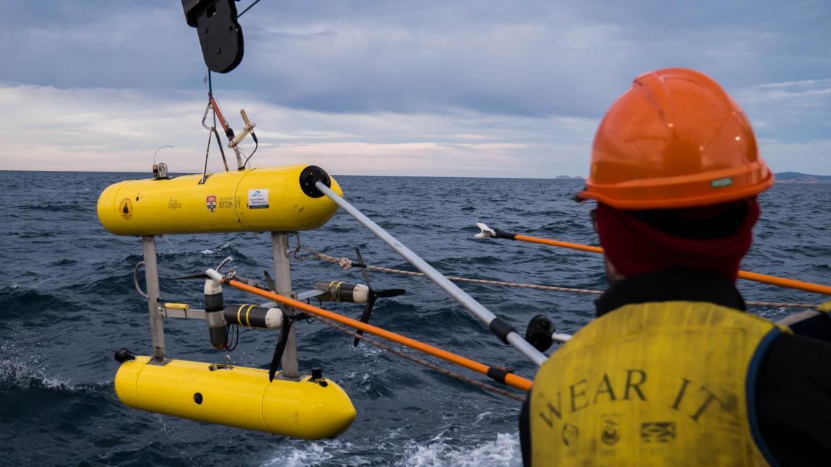
- autonomous underwater vehicles (AUV);
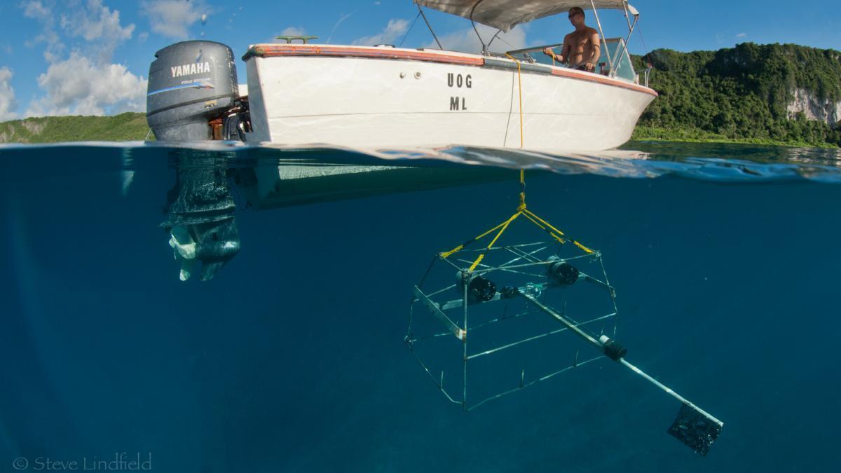
- benthic and pelagic baited remote underwater video systems (BRUVS);
- towed imagery;
- grabs and box corers; and
- sleds and trawls.
Rachel Przeslawski of Geoscience Australia (GA) and Scott Foster of CSIRO led the National Environmental Science Program Marine Biodiversity Hub project that developed the field manuals.
“We have a massive shared responsibility to manage our marine resources and environment,” Dr Przeslawski says. “The manuals provide standardised, national methods for collecting consistent, well-documented and powerful marine datasets showing how things may be changing through time over a larger geographic area.
“These sampling approaches can be incorporated in project proposals and cited in publications, helping researchers make more efficient use of their time and resources. Ultimately, the manuals will contribute to a national monitoring program with pooled datasets of use to us all.”
Research institutions and regulators urged to get onboard
Dr Przeslawski and Dr Foster worked with more than 70 researchers from 30 agencies – including the Integrated Marine Observing System (IMOS) and Australian Ocean Data Network (AODN) – to refine the current thinking on marine data collection. Togetherthey ensured consistencies across the various sampling platforms, which are rarely used in isolation.
“It was vital for this to be a collaborative effort, so we tapped into the desire of most researchers for robust, well-documented data collection, and sought advice from research, government, regulatory and commercial agencies,” Dr Przeslawski says. “This increases the potential for the standards to be adopted across multiple agencies and monitoring programs.”
IMOS Director and Chair of the National Marine Science Committee, Tim Moltmann, is encouraging institutional partners to adopt the standards as a part of the pathway towards developing national baselines and long-term monitoring.
“Using standard operating procedures will allow us to build bigger datasets and longer time series because field work done by different organisations in different places at different times will produce outputs that are nationally consistent,” Mr Moltmann says. “The Marine Biodiversity Hub can ensure this happens in all of the field work it supports, and IMOS can ensure this happens in the ongoing field programs it supports.
“We hope to convince regulators to require the same standards to be used in environmental impact assessments and operational monitoring programs. The research and development sector, government agencies, consultants and marine industries working together in this way would be a great outcome for Australia’s blue economy.”
Meeting the needs of national reporting
Marine Biodiversity Hub director, Nic Bax, points to the Hub’s integration of shallow reef data for State of the Environment 2016 as an example of successful national data integration.
“We combined data from Reef Life Survey, the University of Tasmania Long-Term Temperate Marine Protected Area Monitoring program, and the Australian Institute of Marine Science Long Term Monitoring program into the most comprehensive marine biological dataset in State of the Environment (SOE) 2016,” Professor Bax says.
“Unfortunately we were unable to integrate shelf reef data, and this was one of the failures of SOE 2016. This is now being addressed by national BRUVS and AUV working groups, underpinned by the standard operating procedures outlined in the field manuals.
“I anticipate that through the standard operating procedures and national working groups we will have a much greater impact on SOE 2021, with more focussed information on the status of in situ marine biodiversity, to match the already extensive data that we have on pressures and the performance of extractive industries.”

Designing surveys to support evidence-based management
Scott Foster led the team that produced the Survey Design Field Manual. He says that while monitoring is the tool for gathering objective knowledge (especially about trends), it is more than just a series of surveys.
“To enable effective monitoring, data collection needs to be coherent and standardised to support evidence-based decision-making,” Dr Foster says. "Standardisation also reduces extraneous variation, increasing the amount of accessible information contained in data.”
Dr Foster says monitoring and surveying should start with defining the research question, and that leads to designing where and how to sample, and how to get as much useful information as possible from your investment.
“A researcher who chooses sampling sites based on where they expect to see the most biodiversity won’t be able to make any statements about an entire reef system or marine park, as they won’t know how representative the chosen sites are of the system," he says. "The simple solution is to randomise the sampling locations, possibly including an increased emphasis on locations with particular environmental conditions."
He says a randomised spatially-balanced survey design was used in 2014–2015 to develop a monitoring baseline at Geographe Marine Park south of Perth, an area initially thought to contain only about five percent seagrass. The sampling revealed the area to be 40 percent seagrass, but this would not have been discovered had the researchers sampled only where seagrass was thought to be present.
Maximising the value and quality of marine data
Vanessa Lucieer of the University of Tasmania Institute for Marine and Antarctic Studies led the team that produced the Multibeam Echosounder Field Manual, which covers procedures such as mapping speed, scale and resolution, data collection, validation and processing. She says that standardisation, hand in hand with open data, is the way forward for marine research.

“Our capacity to learn about ocean ecosystems is limited by the cost of surveys and data assimilation,” Dr Lucieer says. “Seafloor mapping is a big investment in equipment, skills and ship time, so we need to build efficiencies and collaborations that maximise the quality and value of our data. If the aim is to compare data nationally or over time, we need to know that the differences we see are real, and not a feature of different approaches.”
Dr Lucieer says the manuals will help to streamline and bring clarity to all stages of the research process, bridging gaps between the people who fund, collect, process and use ocean data.
“They will foster efficiencies through consistency and transferability that will enable us to answer the bigger questions as part of a collaborative group,“ she says. “We’ll spend less time on data processing, and provide more rapid, multidisciplinary responses to contemporary questions, plus accessible, comparable and consistent data products for stakeholders.
“Having standard validation procedures for covering such contingencies can also provide a safety mechanism to help to prevent mistakes.
"For example, acoustic mapping in the Flinders Australian Marine Park identified an area that looked like sandy seabed. But after noticing a lone sponge, we realised there must be bedrock underneath the sediment. Had we had a sub-bottom profiler on board we could have confirmed this.
"Next time we map in this sediment-veneer habitat (thin layer of sediment covering low-profile reef) we will ensure we have the right tools for the job.
“It sounds simple, but without standards, no two people are going to approach it the same way. It’s a bit like baking a chocolate cake: anyone can do it, but if you want to go into mass production, you all need to follow the recipe. We need to work collegially and work on nationalised questions; the days of working in silos are gone.”
Making biological samples worthy, classifiable and storable
The field manuals also cover the pre-planning steps needed for a successful marine survey. Kirrily Moore of the Tasmanian Museum and Art Gallery has first-hand experience of the problems that can occur when biological sampling happens without sufficient standardisation and pre-survey planning.
“The collection of samples is just the small tip of an enormous iceberg lagging behind the project,” Dr Moore says. “These samples are precious: they may be from remote places, very expensive to obtain and of great value to other researchers, if they can be sure how and where they were sampled.”
“Pre-survey planning which sets out explicit steps like standardised sampling techniques with standardised labelling/numbering recommendations would remove a lot of the guessing and forensic work we currently do. It should also consider who will work on unidentified samples, and how they will be stored in the long-term.”
Sharing data via national platforms
The move towards standardisation facilitated by the field manuals is happening alongside the development of national and international facilities for storing, accessing and sharing marine data. Together they will give unprecedented capability to analyse marine data and deliver marine biodiversity information of value to marine managers and scientists.
Dr Ariell Friedman of Greybits is a developer of Squidle+ and GlobalArchive, online platforms for storing, exploring and annotating georeferenced images and videos. He says a lack of standardisation in methods and annotation complicates the already lengthy and laborious manual processing needed to transform the data into quantitative information. This limits the potential of the copious amounts of georeferenced underwater visual survey data now being collected to contribute to scientific conclusions or guide management and policy.
Other national data platforms in line to benefit from the advent of standardised marine sampling field manuals include:
- Seamap Australia (a nationally synthesised collection of marine seafloor habitat data);
- the Ocean Biogeographic Information System (OBIS Australia) and Atlas of Living Australia (collaborative aggregators of biodiversity data);
- the AuScope Virtual Research Environment project (building a virtual laboratory for geoscience datasets);
- AusSeabed National Coordination program for marine bathymetry data (in development by GA-led consortium); and
- the online BRUV analysis Marine Research Data Cloud platform (in development by IMOS-AODN).
Showing our research to the world
Prof. Bax, who co-chairs the Biology and Ecosystem Panel of the Global Ocean Observing System, says the standard operating procedures would help Australia increase its impact in national and international debates.
“The value of our work is hampered by a lack of consistent approaches that makes it difficult to identify trends at the national or international level,” he says. “This restricts our ability to contribute to the products that policymakers read, such as Australia’s SOE reporting, or the United Nations World Ocean Assessment. The Hub is in the fortunate position of being able to develop these standard operating procedures for Australia and contribute them to the world community.”
The field manuals have been loaded onto the Ocean Best Practices repository, a searchable international platform that houses global standard operating procedures, manuals and guidelines to facilitate the development of global ocean best practices. Dr Przeslawski says that by harnessing such an international audience, uptake of the manuals and feedback about them will increase, providing a global mechanism for continual improvement.
We want your feedback!
Towed video surveys complete at Bunurong #MPA with @ParksVictoria using @NESPmarinehub SOPs and #sonar for spatially balanced design. pic.twitter.com/G5fbDOg9nd
— Daniel Ierodiaconou (@Dr_Dan_I) April 25, 2018
The manuals will be tested in coming months during surveys conducted by the Hub in the Beagle and Hunter Australian marine parks, and by Deakin University for coastal and marine park monitoring in Victoria. They will be updated regularly for highly complex or technical platforms such as AUV and multibeam echosounder, to include new technological and scientific developments, including those related to data discoverability and accessibility.
The Hub encourages the development of new manuals, or the publication of existing standard operating procedures, for additional gear types (platforms). These may cover remotely operated underwater vehicles, drop cameras, environmental DNA (eDNA) measurements and surveying of microplastics. Anyone interested in leading or contributing to new manuals should email rachel.przeslawski@ga.gov.au.
Feedback is encouraged from potential users and stakeholders to improve future versions of the manuals and can be provided at: www.surveymonkey.com/r/NZRLMHB
Related links
- Log in to post comments