The North Marine Bioregion is home to a diversity of threatened and data-poor marine species. In the absence of critical data on species’ distributions, population connectivity, and essential habitat, decision-making to progress the current ‘Developing the North’ agenda has the potential to negatively impact Matters of National Environmental Significance. Data compiled across multiple sources were used to model and map the distribution of 16 priority Threatened and Migratory marine species. The objective of the project was to improve the current data-poor species distribution maps held by DAWE to assist with policy decisions for these species. We used a spatial distribution modelling approach based on presence data for these species from 121 spatial datasets and associated, remotely sensed environmental variables. The output is a series of distribution maps to enhance decision-makers’ ability to assess potential impacts of development proposals in Northern Australia under the EPBC Act.
%8 20 Jul 2021 %G eng %0 Report %D 2018 %T Scoping a seascape approach to managing and recovering northern Australian threatened and migratory marine species %A PM Kyne %A Michele Thums %K Indigenous sea-country %K marine turtles %K migratory species %K rapid assessment %K sawfishes %K shorebirds %K threatened species %XNorthern Australia is currently the focus of substantial economic development, which also has the potential to impact biodiversity and cultural values. The Northern Seascape scoping project (NESP Marine Biodiversity Hub Project A12 Phase 1) assessed the state of knowledge of Commonwealth Environment Protection and Biodiversity Conservation Act 1999 (EPBC)-listed Threatened and Migratory marine species, and pressures, Indigenous priorities, coastal habitats, and fisheries bycatch in relation to them across the North Marine Bioregion. The focus was at a multiple taxa level, including elasmobranchs (sharks and rays), shorebirds, marine turtles, Dugong, and cetaceans. The project scoped the research needs and directions for a broad Northern Seascapes project for the years 2018–2020.
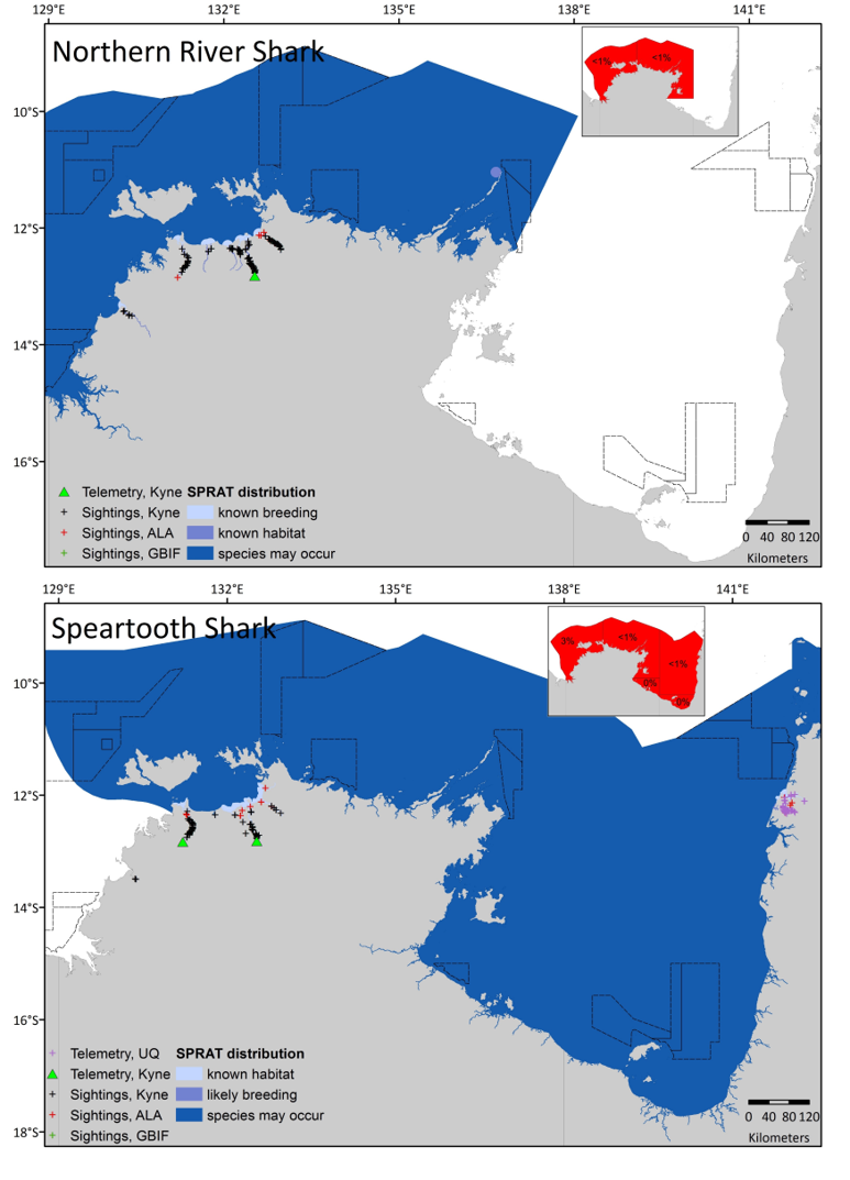
Figure 2 Northern River Shark and Speartooth Shark
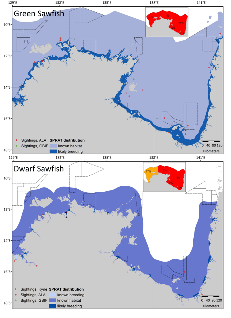
Figure 3 Green Sawfish and Dwarf Sawfish
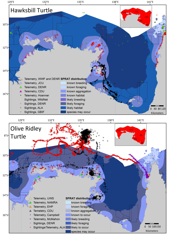
Figure 5 Hawksbill Turtle and Olive Ridley Turtle
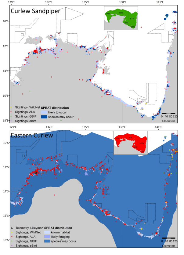
Figure 6 Curlew Sandpiper and Eastern Curlew
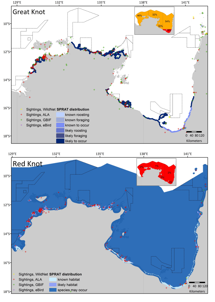
Figure 7 Great Knot and Red Knot
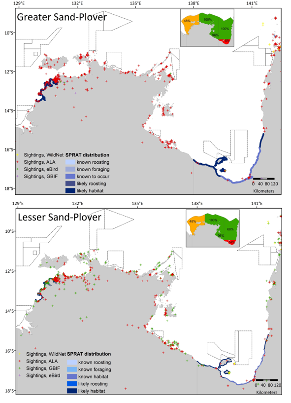
Figure 8 Greater Sand-Plover and Lesser Sand-Polover
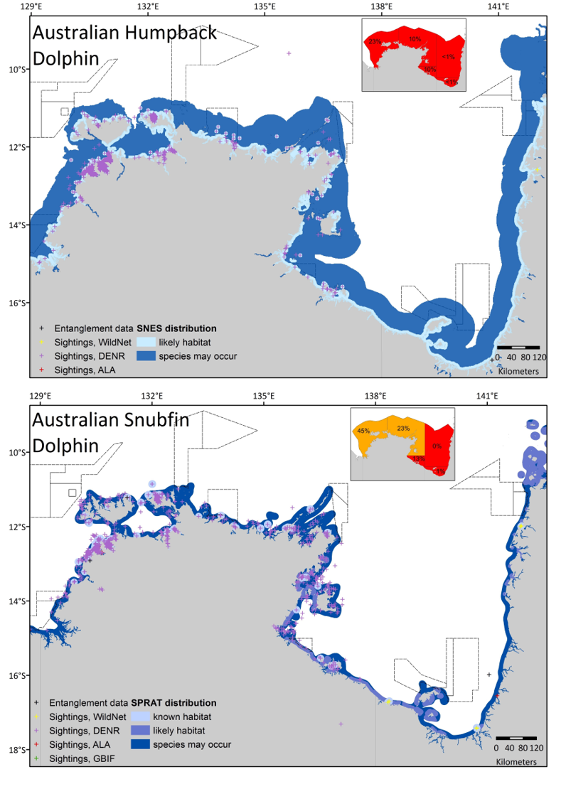
Figure 10 Australian Humpback Dolphin and Australian Snubfin Dolphin
%8 14 Sep 2018 %G eng %0 Report %D 2017 %T Ecosystem Understanding to Support Sustainable Use, Management and Monitoring of Marine Assets in the North and North-West Regions: Final Report 2016 %A Karen J Miller %A Puotinen, ML %A Rachel Przeslawski %A Z Huang %A Phil J. Bouchet %A Ben Radford %A Jin Li %A Johnathan T. Kool %A K Picard %A Michele Thums %A Jessica J. Meeuwig %A Scott L Nichol %K CMR %K gap analysis %K north region %K north west region %K predictive modelling %X
Effective management of marine assets requires an understanding of ecosystems and the processes that influence patterns of biodiversity. Project D1 of the NESP Marine Biodiversity Hub has been collating and synthesising existing data through 2015/16, focusing on Commonwealth Marine Reserves (CMRs) and Key Ecological Features (KEFs) of the North and North-west regions of Australia’s marine estate, with three main objectives:
Building on the North West Atlas (www.northwestatlas.org) as a communication platform, we collated 179 data sets for the North and NW Regions, and these are now accessible online. Targeted syntheses of knowledge for the Oceanic Shoals CMR and the Ancient Coastline KEF were used to demonstrate the value of this approach for informing marine planning and management and highlighting uncertainty.
Based on collated data sets, we undertook a formal gap analysis across CMRs and KEFs of the North and NW regions to identify those areas for which there exists sufficient data to underpin spatial predictive modelling in future years. Our results highlight the patchiness of available biophysical information, and large differences in coverage among taxa across the CMR network. We considered that the Kimberly CMR was the only area across the North and NW region for which existing data might underpin accurate spatial predictive modelling in the future. Our gap analysis did highlight CMRs and KEFs for which information coverage is greatest, as well as areas in which targeted empirical data collection would both inform future management and planning and enhance our capacity to use predictive models for ecological inference.
We used the Oceanic Shoals CMR as a case study for assessing the value of spatial predictive models in delivering knowledge of habitats and species distributions in remote, unsampled areas. We predicted the distribution of a range of biological and physical characteristics across the entire CMR, including benthic habitats, pelagic species, sponge diversity, and sediment type and hardness. This exercise shows the value of this approach for identifying assets in the marine estate where it is impossible to collect comprehensive data, and is a guide for stakeholders in identifying future data needs and tools required to adopt a similar approach nationally. The Oceanic Shoals predictive modelling example also provides a perspective on how modelling performance needs to be considered in the interpretation of predictive model outputs and maps.
Innovative science continues to support the effective management of Australia’s marine estate. In addition to the data collation, synthesis and modelling, the Project D1 team has been developing a range of manuscripts for publication in the peer-reviewed literature. A summary of key findings and progress of eight papers that collectively value-add to past NERP and present NESP research in the North and NW Regions is provided. Novel science discoveries include the identification of pelagic fish hotspots, environmental predictors of flatback turtle behaviour, impacts of cyclones on turtle movements, and descriptions of potential biological and geomorphic values in the Oceanic Shoals CMR.
The work undertaken to date as part of Project D1 has created an easily accessible knowledge framework for the Oceanic Shoals CMR and the Ancient Coastline KEF that will directly inform the development of management and monitoring plans in these areas.
We have demonstrated how spatial predictive modelling can be used to fill knowledge gaps and hence form a foundation for the evolution from precautionary management based on minimal information to more effective management based on a more rigorous scientific understanding of ecosystems. We also identified CMRs and KEFs where similar approaches can be implemented easily or with minimal additional investment in field data capture. The methods illustrated here for the North and NW regions provide a template for the application of similar approaches to other regions of Australia, where similar data are available or could be obtained, in particularly for supporting additional KEF characterisation and CMR monitoring and management.
%8 29 Nov 2017 %G eng %0 Journal Article %J Endangered Species Research %D 2017 %T Environmental predictors of foraging and transit behaviour in flatback turtles (Natator depressus) %A Michele Thums %A Waayers, D %A Z Huang %A Pattiaratchi, C %A Bernus, J %A Mark Meekan %K Key ecological feature %K Kimberley %K Lacepede Islands %K migration %K Sahul Shelf %K Satellite tracking %K State-space model %K Telemetry %K Tidal fronts %K ·Inter-nesting %XSea turtles migrate between nesting beaches and foraging grounds, but little is known about the cues they use to direct these migrations, and the habitats that define their foraging grounds. Here, we used satellite telemetry to follow the movements of 11 flatback turtles Natator depressus after nesting on islands in the waters off the coast of the Kimberley region of northern Australia. State-space models were used to objectively define inter-nesting, migration and foraging behaviour during the 327 ± 315 d (mean ± SD) that the turtles were tracked. These animals migrated along the coast in water depths of 63 ± 5 m to foraging grounds on the mid-Sahul Shelf in the Timor Sea in average water depths of 74 ± 12 m, 135 ± 35 km from shore. Distribution modelling showed that flatback turtles preferred foraging and transiting in clear waters (suspended material <0.06 g m−3), 60 to 90 m deep and in association with complex, benthic geomorphology (banks, shoals, terraces, deep holes and valleys) thought to support a high abundance of sessile invertebrates, the likely targets of their foraging. Distance to the tidal front was also a strong predictor of turtle migratory behaviour, with the animals potentially following tidal fronts along the Kimberley coast. Our study identified both critical habitats for this species and the environmental variables that predict their migration and foraging. This information is important to aid spatial planning of conservation for this data-deficient species that is endemic to northern Australia.
%B Endangered Species Research %V 32 %P 333 - 349 %8 04 May 2017 %G eng %U http://www.int-res.com/abstracts/esr/v32/p333-349/ %! Endang. Species. Res. %R 10.3354/esr00818 %0 Report %D 2015 %T Developing a toolbox of predictive models for the monitoring and management of KEFs and CMRs in the North and North-west regions - Scientific Workshop Report %A Rachel Przeslawski %A Karen J Miller %A Scott L Nichol %A Phil J. Bouchet %A Z Huang %A Johnathan T. Kool %A Ben Radford %A Michele Thums %XA scientific workshop for NESP Project D1 ‘Developing a toolbox of predictive models for the monitoring and management of KEFs and CMRs in the North and North-west regions’ was held at Geoscience Australia 9-10 September 2015. The objectives of the workshop were to discuss future research priorities for the North and North-West regions and to define current knowledge gaps by consolidating existing datasets from AIMS, GA and UWA. Several robust datasets for the North and North-West region were identified which may be used to validate, refine, or extend existing models, particularly in the Oceanic Shoals CMR and along the North-west coastline, including the Kimberley CMR. There are still large regions for which very little scientific information exists, notably the Argo Rowley Terrace CMR and other deep-sea areas. However, when balanced against stakeholder interests and marine management priorities, data-poor CMRs closer to the coast such as the Kimberley and 80 Mile Beach CMRs are the most likely candidates for future research.