December 13, 2013
A marine biodiversity survey in the Oceanic Shoals Commonwealth Marine Reserve (Timor Sea) has added to the knowledge base of Australian tropical shelf habitats, and the data will be used to inform management of these poorly understood areas.
The survey location was determined in discussion between the NERP Marine Biodiversity Hub and the Department of the Environment and focuses on the carbonate banks and terraces recognised in the North and North-West Marine Bioregional Plans as a Key Ecological Features.
Marine Hub scientists from the Australian Institute of Marine Science (AIMS), Geoscience Australia (GA), the University of Western Australia and the Museum and Art Gallery of the Northern Territory, surveyed four areas in the western sector of the reserve in September-October 2012 from the AIMS Research Vessel, RV Solander.
They found the area to be geomorphically diverse, with sandy carbonate banks and shoals separated by muddy plains and valleys. The waters on and around the shoals were highly turbid due to suspended sediments transported by strong tidal currents that are thought to influence the pattern of benthic communities.
The biodiversity of epibenthic fauna, such as sponges and corals on the carbonate banks, appears to be responding to a mix of water depth, light and turbidity, with higher biodiversity on shallower banks of less than 45 metres.
The species richness and endemism of sponges appeared higher than had previously been found in the eastern sector of the reserve.
Demersal fish communities were larger and more diverse on the shallower, less turbid banks (consistent with patterns of benthic biodiversity), and a wide variety of high-order pelagic fish species was observed.
The sampling and data acquisition included:
- photographs and videos of seabed habitats and associated biological communities, including demersal and pelagic fish;
- continuous high-resolution multibeam sonar bathymetry and acoustic backscatter and sub-bottom acoustic profiles;
- seabed sediments and biota including sponges, corals and infauna;
- observations of high-order pelagic predators, including whales and dolphins; and
-
oceanographic measurements, including the release of 10 ocean drifters to track surface currents.
Marine Hub scientist Scott Nichol said the survey results had been subject to consistent sampling and processing protocols that ensured a uniform data standard for analysis and interpretation.
The field collection is only the first stage in a much longer process of laboratory work and analysis involving the partners and Australian museums to extract the most useful information from the survey data and archived samples.
Researchers will use the data from this survey, combined with data collected previously from the eastern part of the Oceanic Shoals CMR, to develop regional scale maps and models of benthic habitats, ecosystem processes and associated biodiversity.
Marine Hub scientists are working with Parks Australia to identify how these new datasets and knowledge will be used to manage reserves so it can be packaged for use by reserve managers.
More broadly, the statistical design and data-acquisition techniques, such as pelagic baited remote underwater video cameras, evaluated during the survey will contribute to the developing blueprint for national monitoring of marine reserves.
Further reading
- Download the Oceanic Shoals Commonwealth Marine Reserve (Timor Sea) Biodiversity Survey: GA0339/SOL5650 Post-Survey Report
- Visit the blog of the Research Vessel Solander and its survey of the Oceanic Shoals in September/October 2012
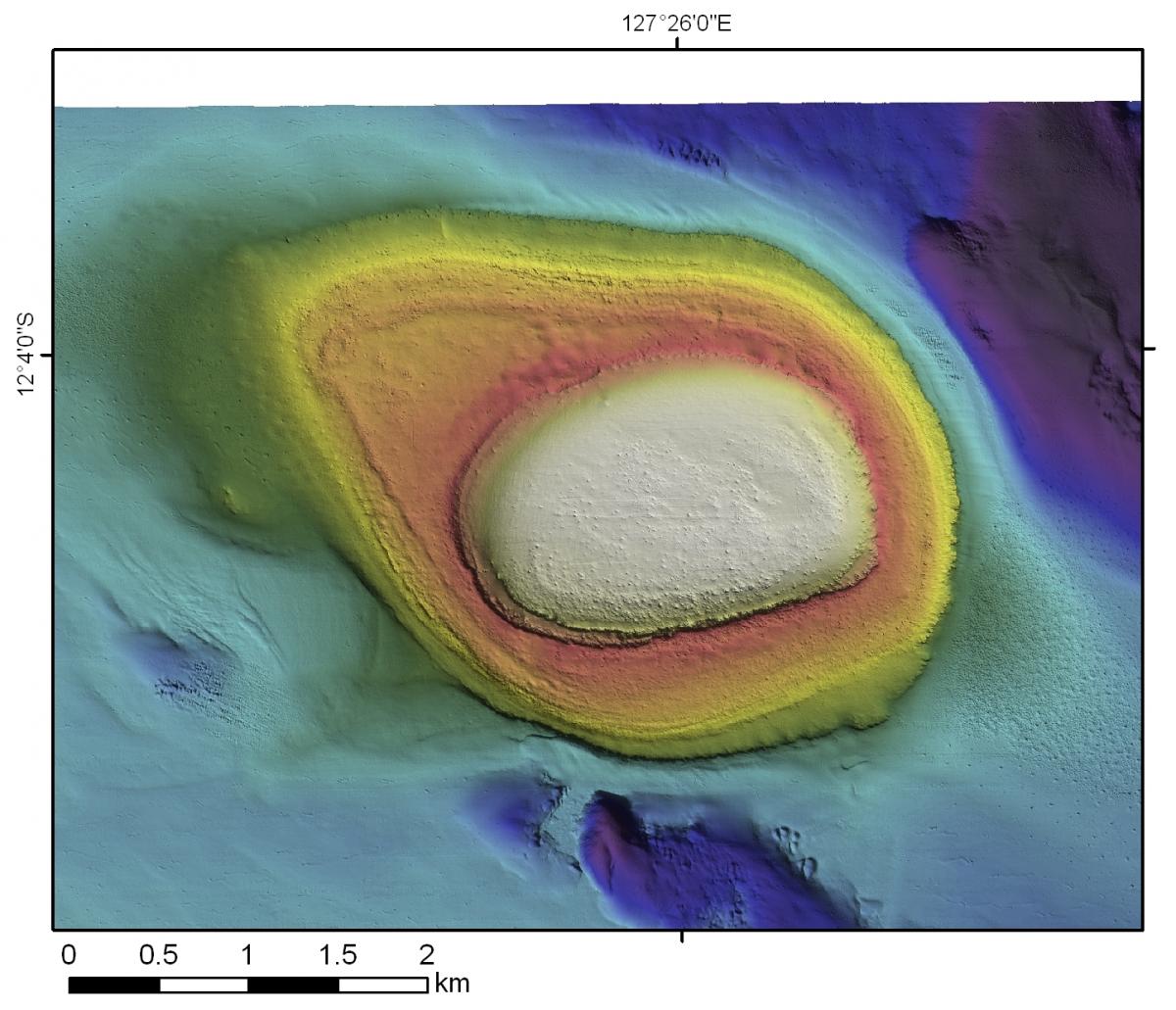
Image
High resolution bathymetry image of one of the shoals mapped during the survey. Water depths range from 30 m on the top of the shoal to 110 m on the surrounding plains.
Contact:
Dr Scott Nichol, Geoscience Australia
- Log in to post comments