Little is known about the deep waters of Australia’s marine parks. While surveys supported by the Marine Biodiversity Hub have visited eastern abyssal depths and Tasmanian seamounts, Western Australian areas were lesser known.
In collaboration with the Western Australian Museum and Geoscience Australia, this project targeted two biologically unexplored submarine canyons (Cape Range and Cloates Canyon) to understand and map the distribution and diversity of their marine habitats and biota. These canyons were targeted to better understand their ecological significance as a conduit between shelf environments adjacent to the Ningaloo Reef and the abyssal plain. They occur within the habitat protection and multiple use zones of the Gascoyne Marine Park off north-western Australia.
Multibeam sonar was used to map parts of the marine park, while a remotely operated vehicle (ROV) SuBastian was deployed to undertake a comprehensive taxon inventory of the north-west canyon fauna based on underwater imagery and sampling. Additional data were collected outside the scope of this Marine Biodiversity Hub project (e-DNA, plankton samples, fish traps).
Key drivers for this survey were to collect information to enhance our understanding of Gascoyne Marine Park and deep-sea environments throughout Western Australia, and to facilitate comparisons between the north-west and eastern and southern Australian deep-sea waters.
The survey confirmed that canyons within Gascoyne Marine Park are ecologically important systems, supporting numerous deep-sea species, many of which were discovered to be new to science. This information can be applied to marine park management, scientific research and industry activities for the north-west region. Specifically, this survey provided:
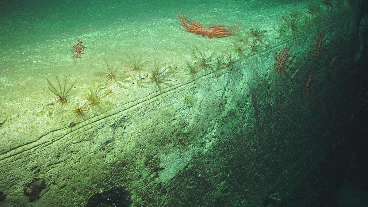
- A faunal inventory as baseline information for monitoring deep water WA environments. A total of 2570 seafloor images were annotated from 12 quantitative transects in Cape Range Canyon, more than 1000 samples were curated and up to 30 new species discovered across both Cape Range and Cloates Canyons.
- High-resolution mapping of the seafloor across an area of 11,250 km2.This detailed information on seabed habitats and environments in Gascoyne Marine Park provides a regional context in which to interpret the faunal inventory.
- Repeat multibeam mapping of the Cape Range and Cloates Canyons informed our understanding of seabed stability in the canyons of Gascoyne Marine Park, illustrating an application of seabed mapping to support monitoring in Australian waters.
- 20 deployments of a state-of-the-art ROV helped inform a new ROV field manual (Monk et al., 2020), which has been added to the existing suite of standard operating procedures used to guide marine sampling in Australian Marine Parks (https://marine-sampling-field-manual.github.io/).
The advanced capabilities of the ROV SuBastian to navigate and image complex (near vertical) walls and overhangs within the canyons revealed patterns in the distribution of the seafloor taxa consistent with small-scale environmental variability. Repeat multibeam mapping revealed a dynamic canyon system that continues to be shaped by turbidity currents.
The occurrence of reworked seagrass blades within the canyons provided a new understanding of these canyon systems as an active conduit between shallow shelf and abyssal environments. The distribution of the seabed biota revealed through quantitative ROV transects emphasised the importance of disturbance patterns in shaping the canyon ecosystems.
The also survey also provided data and information for these Hub products:
- A summary of knowledge about the broader Gascoyne Park, part of an 'eco-narrative' series for Australia’s individual Marine Parks. Eco-narratives are intended to enable managers and practitioners to rapidly ascertain the ecological characteristics of each park, and to highlight knowledge gaps for future research focus.
- A flythrough combines bathymetry with high-resolution imagery to highlight canyon environments within the Gascoyne Marine Park