May 17, 2010
Roland Pitcher, CSIRO - Leader, CERF Prediction Program
Brendan Brooke, Geoscience Australia - Leader, CERF Surrogates Program
A major milestone of the CERF Marine Biodiversity Hub has been achieved. The collation of extensive new and updated datasets of seabed physical variables and broad-scale biological survey records was an immense task only just completed. These new datasets are driving our research forward and at the Department of the Environment, Water, Heritage and the Arts’ (DEWHA) request we are developing new national analyses to support their regional planning.
Physical and biological data are being used to investigate the relationships between patterns of biodiversity and the physical environment, including the form of biological responses along physical gradients and the potential to predict biodiversity patterns in areas where no biological data have been collected. The physical data sets include: bathymetry and derived slope and aspect, a range of parameters that describe seabed shear-stress generated by currents and wind, sediment grain size and carbonate composition, bottom-water chemistry and nutrients (nitrate, phosphate, oxygen, salinity, temperature, silicate) and their seasonal variation, satellite data for chlorophyll, light attenuation, sea surface temperature and their seasonal variation, and seabed irradiance. The source point data for the existing data have been updated by the Hub and new interpolations have been produced as grids with a cell size of ~1 km2. Maps of the distribution of some of the ~30 variables are shown below.
Available biological datasets that are suitable for biodiversity prediction have been scoped and acquired from various sources, primarily Hub partners. These include datasets that extend over a wide range of contrast in the physical variables, and have broad coverage of taxa, which mostly comprise survey presence/absence/abundance datasets collected in the following biomes and regions:
(a) Continental shelf & slope survey datasets from the Great Barrier Reef, Torres Strait, Gulf of Carpentaria, North West Shelf, Southeast Shelf, and wide areas of Slope. The survey methods include: fish trawl, prawn trawl, benthic sled and towed video.
(b) Tropical coral reefs survey datasets from the Coral Sea, Great Barrier Reef, Torres Strait, Timor Sea, North West Shelf, and Ningaloo Reef. The survey methods include: UVC transects for reef fish and reef benthos morphotypes.
(c) Southern temperate rocky reefs survey datasets from Tasmania, New South Wales, Victoria, South Australia, and Western Australia. The survey methods include: UVC transects for fish, macro-algae, and mega-invertebrates.
The site locations of the acquired datasets are mapped below. A number of additional data sources are currently being investigated that may have the potential to fill some of the gaps across southern and north-western Australia. Also, to enable relationships between physical variables and seabed biodiversity to be measured at fine spatial scales (10s – 100s m), new shelf datasets have been collected by the Hub in south-eastern Tasmania, the Carnarvon Shelf in Western Australia and Jervis Bay in New South Wales.
The new datasets are now being analysed by the CERF Marine Biodiversity Hub scientists in project teams that extend across the partner organisations, in consultation with the Hub stakeholders.

Map of site locations for all biological data collated in 2008, categorised by biome: Shelf, Slope, Coral Reefs, and Temperate Reefs.
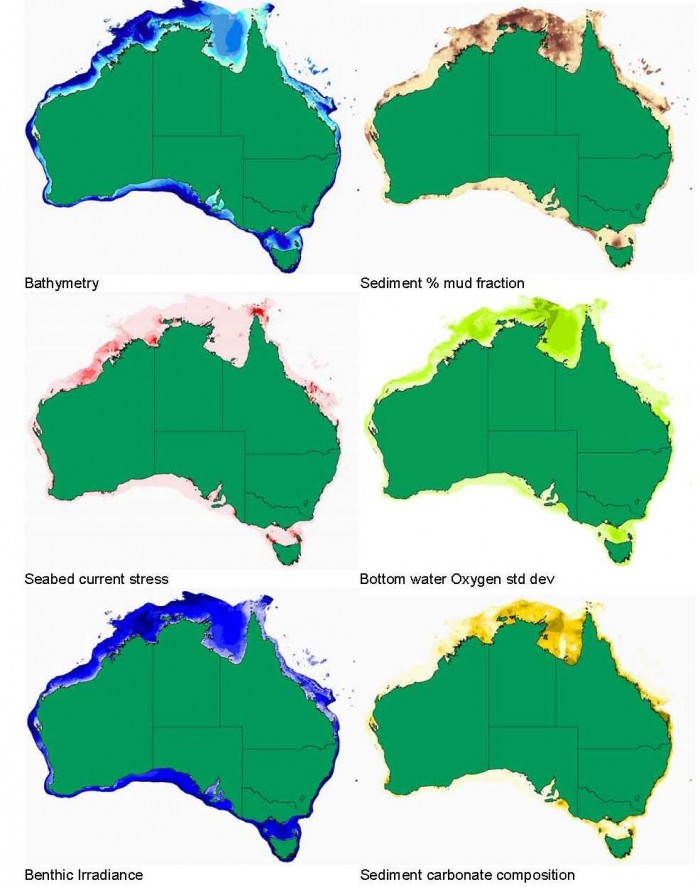
Maps of selected physical variables on Australia’s continental shelf that have been associated with patterns in seabed biodiversity data.
- Log in to post comments